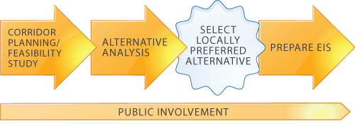
Study overviewNassau County has initiated the preparation of an Alternatives Analysis (AA) to address transportation problems in the area known as Nassau Hub. The Nassau Hub Study will define new transportation options and identify land use strategies that will help promote economic development, create jobs in the Study Area, and improve access and mobility, which in turn, will enhance the quality of life for all Nassau County residents. The AA will examine opportunities for introducing realistic and practical transit improvements within the Hub study area, and will be conducted in cooperation with the Federal Transit Administration (FTA) and in accordance with FTA requirements. The purpose of the AA, as currently defined, is to select a Locally Preferred Alternative (LPA). Following the election of the LPA and with the FTA's concurrence, Nassau County will conduct an environmental review in accordance with the National Environmental Policy Act of 1969. The review will result in a Draft Environmental Impact Statement (DEIS) for public review and comment. Nassau County anticipates a Final Environmental Impact Statement, a Record of Decision and, if successful, federal funding to implement the LPA. Transit projects seeking funding from the FTA New Starts or Small Starts program must follow a standard rocess (see AA/EIS Process Flow Chart). New/Small Starts is the Federal funding program for new transit initiatives and Nassau County must follow a prescribed process to be eligible to receive these funds. An important early step in this standardized planning process is the preparation of an Alternatives Analysis (AA) that documents existing and future transportation problems, evaluates a range of potential alternatives to address those problems, and selects an LPA. An Environmental Impact Statement (EIS) is then prepared to fully disclose the potential impacts of the LPA on the human and natural environment. During both the AA and EIS processes, the public and other stakeholders are given frequent opportunities to review the analyses and provide comments and other input.
AA/EIS Process Flow Chart
background In 2003, the Nassau County Planning Department began efforts to position the County to be eligible for Federal grants related to improving, upgrading and extending the transit network within the County, specifically the tudy Area. The results were documented in the 2006 Nassau Hub Major Investment Study Final Report (the MIS) that examined and analyzed the demographic, economic and transportation issues within an area known as the Nassau Hub." The MIS concluded that the County should further study potential transit and related land use improvements, within the context of the FTA's project development process. previous studies In 2003, the Nassau County Planning Department began efforts to position the County to be eligible for Federal grants related to improving, upgrading and extending the transit network within the County, specifically the tudy Area. The results were documented in the 2006 Nassau Hub Major Investment Study Final Report (the MIS) that examined and analyzed the demographic, economic and transportation issues within an area known as the Nassau Hub." The MIS concluded that the County should further study potential transit and related land use improvements, within the context of the FTA's project development process. Over the years there have been multiple efforts initiated to study the transportation, land use and economic issues within the Study Area. These studies include:
Additional pertinent studies that have examined Nassau County and/or Long Island as a whole include:
These studies identified problems of growing roadway congestion, a limited transit system, slowed population growth and an overall stagnation of economic growth. Additionally, these studies identified strategies for directing growth to existing downtowns and targeted development areas, including the Study Area, as well as encouraging the use of public transit as a means of supporting growth without further exacerbating traffic congestion. The MIS was the only one of the above studies conducted pursuant to FTA requirements. Faced with stagnant economic growth, an ever-increasing property tax burden and traffic congestion that continues to worsen, the County determined that a new paradigm was necessary for the future sustainable growth of the County. Accordingly, the County commissioned The Nassau Hub MIS in 2003 to review new transportation options and supportive land use development strategies that would result in improved access and mobility, support economic development opportunities, and enhance and preserve the high quality of suburban life that residents had come to expect. The MIS laid the groundwork and established the starting point for this current AA. The MIS identified problems and needs in the Nassau Hub, including:
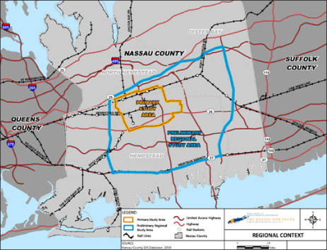
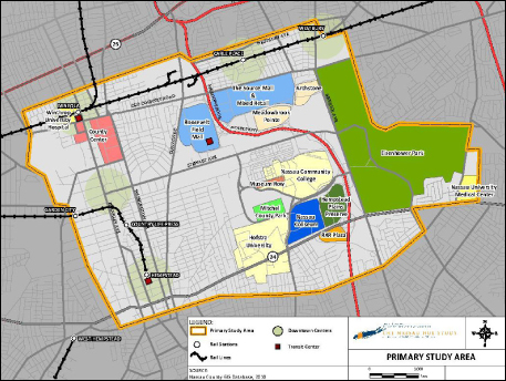
After significant technical analysis and public outreach, the MIS concluded that a potential series of transit projects should be advanced into the FTA New Starts/Small Starts process beginning with the completion of an AA, the selection of an LPA, and the completion of a NEPA EIS. This Problem Statement is one of the initial work elements in this process. Primary study area The Nassau Hub Primary Study Area (Study Area) occupies an approximate 11.7 square-mile area in the heart of Nassau County, and is home to Hofstra University (existing campus and planned medical school), Nassau Community College, Museum Row, the Nassau Veterans Memorial Coliseum, the County Government Center, Nassau University Medical Center, Mitchel Field / Eisenhower Park, Roosevelt Field, and other notable County features. Additionally, thousands of residents, employees, students and others live and work within the area. This crucial economic center, so vital to the future of Nassau County, has substantial traffic congestion, lacks efficient and direct transit choices and includes large areas of disjointed land use patterns. These factors have contributed to long commutes, decreased environmental quality, and overall difficulty in traveling to, from and within the area. The Primary Study Area is the focus of this Study and is where it is anticipated that the majority of physical improvements associated with any given alternative may occur. During the MIS, a Study Area boundary was established based on the nexus of major roadways, transit stations and infrastructure, major land-use features and institutions and principal trip origins and/or destinations that might benefit from transit and mobility improvements. The MIS' Study Area northern boundary was located just to the north of the LIRR's Port Jefferson Branch, while the southern boundary was just to the south of empstead Turnpike. The western boundary ran along Rockaway Avenue and Cathedral Avenue, and the eastern boundary was Eisenhower Park. It included all or parts of the Villages of Mineola, Westbury, Garden City and Hempstead; the Hamlets of Carle Place and Uniondale; and the U.S. Census defined area of East Garden City. This area also included the LIRR stations at Mineola, Carle Place, Westbury, Garden City, Country Life Press, and Hempstead; the Mineola Intermodal Center; the Rosa Parks – Hempstead Transit Center; and the Roosevelt Field Bus Transfer Facility. Finally, major roadways within these boundaries that serve both regional and local destinations include: the Meadowbrook State Parkway, Franklin Avenue, Clinton Road, Merrick Avenue, Hempstead Turnpike, Old Country Road, and Stewart Avenue. The MIS Study Area boundary has been adopted as the starting point for this AA with one modification. The eastern boundary has been extended to incorporate the Nassau University Medical Center's East Meadow campus that is immediately east of Eisenhower Park. It was determined that the Medical Center is integral to any consideration of improved transit because it is a:
The Study Area boundary is not necessarily a hard and fast line. Rather, as the Study progresses with technical analyses and outreach to the public, stakeholders and government agencies, the boundaries may contract or expand if dictated by Study needs. Regional Contect for Study Areas
Primary Study Area
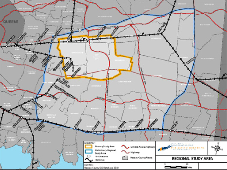
preliminary regional Study Area A Preliminary Regional Study Area (Regional Study Area) has also been defined based on travel patterns, potential opportunities for connections among activity centers, and key economic development opportunities outside the Primary Study Area. Building on the conclusions of the MIS, coupled with a need to incorporate areas that have the greatest potential for economic development, boundaries have been established. These boundaries extend slightly north of Mineola along Jericho Turnpike, on the east to the Hamlet of Bethpage along the Seaford Oyster Bay Expressway, on the south along Sunrise Highway, and to the west along Nassau Boulevard. This expanded area includes portions of the West Hempstead, Babylon and Ronkonkoma Branches of the LIRR; major roadways such as the Northern and Southern State Parkways, the Wantagh State Parkway, Routes 106/107, the Seaford Oyster Bay Expressway, Sunrise Highway and Jericho Turnpike; as well as major town centers such as the Hamlet of Hicksville and the Village of Freeport; and the former Grumman site in Bethpage (currently undergoing redevelopment). The Regional Study Area was established to capture the context of the larger travel market to the Study Area. As noted above for the Study Area, the boundary of the Regional Study Area may be modified if warranted by findings of the Study's technical analyses and/or input from the outreach process.
|
|
 |
||||||||